
Question
- Junior Cert Geography (Common) Edco Sample C Q10
- Back to the question >
Answer
(a)
(i)
(ii)

(iii)
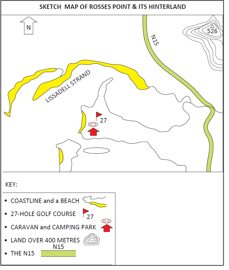
(iv) Marine coastal deposition landforms:
- Beach G 62 40
- Sandspit G 59 42
- Sand dunes at G 59 43
(v) G 644 437: Nature reserve
(vi) Distance: 10.1 cm = 5.05 km
(vii) Direction: North-east
(b)
(i)
(ii) A Special Area of Conservation (SAC) is land designated under Directive 92/43/EEC (the Habitats Directive) on the conservation of natural habitats and of wild fauna and flora. Ireland’s SACs are the main wildlife conservation areas in the country, e.g., the Burren in Co. Clare. This land is considered to be important on a European and an Irish level and is known as a National Park and a Geopark. We try to protect biodiversity and preserve special parts of our landscape, so we restrict planning permissions in these areas.
(iii) Hydraulic action is the power of the water as it smashes against the river banks. The pressure of the river’s power against the banks weakens and gradually wears them away.
(iv) The river is meandering in the old age stage as it approaches the estuary. It has less than 3 km before it reaches Drumcliff Bay, so it is flowing over a flat gradient. The most pronounced meander is at G 695 417.
(c)
(i) Land use: Residential
(ii) A suburb is a mixed-use or residential area that is either part of an urban area or a separate residential community within commuting distance of a city/town. In the photograph you can see detached housing with front gardens and driveways for cars. The area seems well maintained and has footpaths and kerbing, and deciduous trees in the green area. The houses are large and suitable for raising a family.
(iii) A suburb is usually a mainly residential district with infrastructure such as parks, playgrounds and amenities, where people can live and raise families. It is located in the outlying part of an urban area.
(iv) The main disadvantage of living in the suburbs is that it takes longer to reach most destinations, e.g., workplaces and schools. Living in the suburbs often makes for a long commute, especially since public transport (DART, Luas, public buses) is often harder to access, so people depend on their car.
(v) Urban sprawl refers to poorly planned, low-density, car-dependent development that spreads out over large areas of land on the outskirts of towns and cities such as Dublin. There are long distances between homes, shopping centres, factories and business parks. Green spaces on the edge of urban areas are also destroyed.
(vi) Name of city: Tallaght
One improvement made to the inner city area:
Tallaght has grown rapidly and now has a population of 76,119. It is a vibrant, urban settlement as a result of urban renewal. It has its own town centre, a major shopping facility (The Square), civic offices, commercial, financial and community facilities, an institute of technology, a soccer stadium and a hospital. The red Luas line has aided the development of Tallaght by enabling access to the city centre on a reliable light rail public transport system.
How sustainable the scheme has been:
Historically, there were a lot of complaints about the lack of facilities, e.g., sports facilities, and people coming to live in Tallaght from the inner city felt they had been shipped out to public housing in the middle of the countryside in South-west County Dublin, but the area has matured and the urban renewal scheme has been sustainable.